
IHI partners with Kuva Space to add hyperspectral intelligence to sovereign Earth-observation constellation
- MoU marks further concrete step in development of multi-sensor dual-use LEO constellation -
IHI Corporation has signed a Memorandum of Understanding (MoU) with Kuva Space, a Finnish space-technology company developing hyperspectral Earth-observation satellites and AI-powered intelligence solutions, to explore the development and use of hyperspectral satellite capabilities as part of IHI’s planned multi-sensor constellation.
The collaboration will support IHI’s ambition to strengthen Japan’s sovereign Earth-observation and intelligence capabilities, while creating opportunities for dual-use applications across national security, economic security, resilience and civil use cases.
A signing ceremony for the MoU was held on July 17, 2026 at Kuva Space.

From Left
Mr. Jari Sinkari, Director General, Department for Asia and Oceania, Ministry for Foreign Affairs of Finland
Mr. Jarkko Antila, CEO of Kuva Space
Mr. Atsushi Sato , Representative Director and Senior Executive Officer, and President of Aero-Engine, Space & Defense Business Area
Ms. Maiko SATO, First Secretary, Head of Economic section, Embassy of Japan in Finland

Kuva Space is a Finland-based leader in hyperspectral satellite technology developing satellites and AI-powered analytics designed to turn spectral data into actionable intelligence. Following the launch of its first satellite, “Hyperfield-1A” in 2024, and its second satellite “Hyperfield-1B”, the company plans to start launching its next-generation hyperspectral satellites “Hyperfield-2” in 2027. Hyperspectral satellites capture data across a wide range of spectral bands, enabling users to detect and analyze materials, vegetation health, environmental conditions and other characteristics that may not be visible through conventional optical imagery. This makes hyperspectral data relevant first to national and economic security, while also supporting civil and commercial applications such as agriculture and food security, marine monitoring, forest management and carbon credits.
Since last year, IHI has been conducting trials and verification of Kuva Space's hyperspectral satellite data and AI-powered analysis methods. Under this MoU, IHI and Kuva Space will assess priority use cases, define data and system requirements for a future hyperspectral satellite constellation, and explore the optimal business structure for developing hyperspectral satellite capabilities in Japan, including domestic satellite manufacturing.
The MoU also reflects the deepening Japan-Finland relationship in security, economic security and advanced technologies, including space and satellite data. In the 2025 Joint Statement on Strengthening Cooperation in the Future, Japan and Finland recognized the increasingly challenging international security environment and the inseparable nature of European/Atlantic and Indo-Pacific security. In February 2026, the two governments also signed a Joint Statement on Strengthening Cooperation in Dual-Use and Advanced Technology Fields, including space and satellite data.
IHI's partnership with ICEYE has already transformed its satellite constellation ambitions into operational capability, with SAR data acquisition underway since April 2026. The newly signed MoU with Kuva Space marks the next phase of that strategy, broadening IHI's capabilities from all-weather SAR imaging to multi-sensor intelligence. In parallel, IHI is preparing to assemble and test two additional ICEYE SAR satellites in Japan from around September 2026, further strengthening its domestic space capabilities in collaboration with ICEYE.
In November 2025, IHI launched the small hyperspectral satellite IHI-SAT2 and is working to improve its hyperspectral satellite image analysis and satellite operation capabilities. The collaboration with Kuva Space will further accelerate its efforts in hyperspectral satellite development and data exploitation.
IHI’s planned constellation envisions the future integration of multiple satellite types, including optical satellites, VDES (Next Generation Automatic Identification System), radio frequency infrared, hyperspectral and SAR satellites. By combining complementary sensor types, IHI aims to provide more persistent and resilient intelligence for Japan, including target detection and tracking required for land and maritime operations, while supporting deepener cooperation with allies and like-minded nations through the mutual sharing of satellite data and imaging capacity.
Atsushi Sato , Representative Director and Senior Executive Officer, and President of Aero-Engine, Space & Defense Business Area, IHI,
comments: “A secure and resilient space capability is increasingly important for Japan’s national security. Hyperspectral satellite data can provide insights that conventional imagery cannot, supporting both security and wider dual-use applications. This MoU with Kuva Space is an important step in strengthening Japan’s access to hyperspectral intelligence through cooperation with a trusted partner.”
Jarkko Antila, CEO of Kuva Space, comments: "Kuva Space is building hyperspectral satellite and analytics capabilities designed to turn spectral data into actionable intelligence. By working with IHI, we can help bring this capability into Japan’s emerging sovereign Earth-observation architecture and support the pathway from demonstration to operational hyperspectral intelligence”.
*1 Hyperspectral Satellite
A hyperspectral satellite is equipped with a hyperspectral sensor capable of acquiring information across a broader and more detailed range of wavelengths than conventional optical satellite imagery. By analyzing differences in reflection spectra within the image data captured by the hyperspectral sensor, it is possible to estimate the material, condition, and potential anomalies of the target objects.
[ About IHI ]
IHI Corporation traces its origins to Japan’s first modern shipbuilding facility, established in 1853, and has since grown into one of the country’s leading manufacturers. The company has continuously expanded its business and now provides a wide range of solutions across four key sectors: Resource, Energy and Environment; Social Infrastructure; Industrial Systems and General-purpose Machinery; and Aero Engine, Space and Defense. In the field of satellites, IHI AEROSPACE CO., LTD. provides propulsion systems and components for space companies. IHI has also recently expanded into satellite-based services, leveraging satellite data and information to help address customers' operational challenges.
[
About Kuva Space ]
Founded in 2016 in Espoo, Finland, Kuva Space is building the world's first extensive microsatellite constellation with patented hyperspectral camera technology to collect gapless data aimed at solving the world's most pressing issues, such as climate change, food security, and resilience. Combined with its AI-driven analytics platform, Kuva Space delivers reliable and timely global insights and foresights that transform rich spaceborne data into actionable insights users can use for efficient resource management, optimizing operations, and improving profitability sustainably. For more information, visit www.kuvaspace.com.
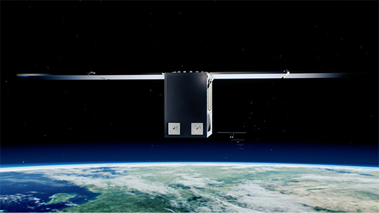
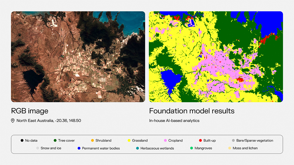
(Both satellite images acquired by Kuva Space’s current satellites)
[ Related Press Release }
22 May 2025
IHI and ICEYE agree to cooperate to develop earth-observation satellite constellation
- Satellites to be manufactured and operated in Japan to strengthen national security - Imagery & capacity could be shared with Japan’s allies & like-minded countries
16 Oct, 2025
IHI and ICEYE agree to build an Earth observation satellite constellation to reinforce Japan’s national security and economic security
28 May, 2026
IHI constellation plan gathers pace with initial data acquisition
First Two ICEYE-Developed SAR Satellites Now Operational, Marking the First Step in IHI’s Sovereign Earth-Observation Constellation