Preserving and Managing Tropical Peatlands Using Simulation Technology
Simulation technology to visualize groundwater levels in tropical peatlands
IHI Corporation
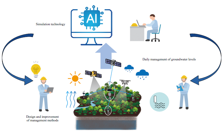
Forestation businesses that operate in Indonesia’s tropical peatlands always need to keep the groundwater levels constant in order to cultivate forests and reduce carbon dioxide (CO₂) emissions. For the purpose of managing groundwater levels, we are developing technologies that estimate the levels based on measurement and observation data from tropical peatlands and operational simulations of water management, and aiming at contributing to society through such development.
Introduction
IHI, with the aim of addressing social issues such as achieving carbon neutrality and preserving biodiversity, established the joint venture NeXT Forest Corporation and has been working to develop various technologies for preserving and properly managing tropical peatlands.
Current state of and issues facing tropical peatlands
A tropical peatland is organic soil (peat soil) formed by accumulating plant remains, such as dead trees, which are immersed in a flooded wetland and therefore decompose excessively slowly. Indonesia has been facing the problem of falling groundwater levels in peatlands due to various factors such as drainage or aridification resulting from the expansion of plantations, the excavation of irrigation channels, or natural drying. This fall in groundwater levels exposes the peat to air, facilitates the decomposition of organic matter, or helps to cause or spread fires, which results in the emission of carbon dioxide (CO₂) that should be stored in peatlands. This has been attracting attention as an environmental issue. To prevent such situations from occurring, groundwater needs to be kept at a proper level. By offering consultation on groundwater level management, NeXT Forest will help to reduce CO₂ emissions from peatlands in Indonesia.
Estimating groundwater levels using simulation technology
Conventionally, we have been operating groundwater level management systems based on groundwater level observations obtained by discrete measurement from the ground surface. In particular, the work of designing groundwater level management relies largely on the knowledge of local experienced management engineers and is often dependent on individual skills. To solve this problem, IHI has been making progress in developing technologies to simulate groundwater levels jointly with the University of Tokyo alongside developing technologies for making accurate measurements in real time using IoT. Previously there have been no cases of developing models that simulate water flow in tropical peatlands that have complicated water channel networks. As the first case, we demonstrated a system that estimates groundwater levels using initial groundwater levels and boundary conditions of time-series rainfall data (observed and forecasted) as inputs. The system presents the estimation results in chronological order.
The procedure to follow before simulation results are evaluated is as follows: (1) analyze measurement and observation data in the past; (2) create a two-dimensional mesh; (3) build a three-dimensional model (hydraulic model); and then (4) perform simulations.
Building a three-dimensional model (hydraulic model)
The hydraulic model is based on the analysis method of coupling equations for groundwater flow and surface water flow. Groundwater flow and surface water flow are found by solving a three-dimensional diffusion equation and a two-dimensional diffusion equation, respectively, as the governing equations. Regarding unsaturated hydraulic conductivity and other parameters, values obtained by utilizing the response surface method, the genetic algorithm, and other analysis methods are set. Based on expertise in this hydraulic model, we analyzed sensitivity to the fluctuation ranges that assume the error components of these parameters and identified parameters that significantly affect the accuracy of groundwater level estimation. As a result, we figured out what we should focus on to improve estimation accuracy and what is important in managing the groundwater levels.
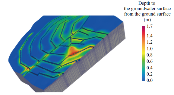
Performing simulations
Based on the built hydraulic model, groundwater level simulations were performed by setting appropriate conditions. Mainly, two types of simulation were performed: one was simulation performed under analysis conditions that assume a steady state (simulation that assumes conditions remain unchanged over time). The other was simulation performed under analysis conditions that assume an unsteady state (simulation that assumes conditions change over time). While the former simulation shows the groundwater level maintenance ability in a target area when average groundwater level management is practiced under average weather conditions, the latter simulation helps managers to know what work to carry out in response to observed or expected rainfall.
Utilizing the simulation model
Through the demonstration of this simulation technology, we came to believe it can be used as a tool that presents basis for operating groundwater level management in existing afforestation plots, and used as a tool that design groundwater level management, present policies on determining measurement locations and design groundwater level management systems for developing new afforestation plots.
Conclusion
We hope that taking advantage of tools that use this simulation model in forest management, including groundwater level management, will help to establish better management processes and lead to efficient, streamlined, and proper preservation and management of tropical peatlands.