Transition from Experience-Based Water Distribution Management to a Data-Driven Approach
Water Distribution Master —A tool that supports water distribution for optimized agricultural water management—
IHI Corporation
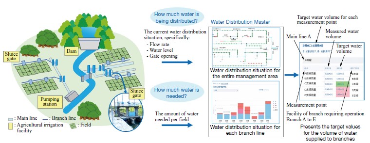
Water Distribution Master, developed by IHI, is a tool that visualizes the uneven water distribution across each branch line of water at a rice field and presents solutions to resolve the uneven distribution. Using the results from this tool, water distribution managers can optimize agricultural water distribution and reduce water waste.
Introduction
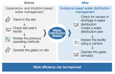
In order to make Japanese agriculture more competitive and sustainable, measures are urgently needed to address issues such as the reduction of working hours, the rising cost of electricity, and the shortage of future farmers. In addition, the frequency of droughts caused by climate change is increasing, making it necessary to take measures to use water resources efficiently. Therefore, we have developed a water distribution support tool called “Water Distribution Master” that uses data collected by a water management system to monitor and remotely operate agricultural irrigation facilities. This article provides an overview of the tool and how to use it. The users of this tool are individuals involved in water distribution management (land improvement district staff). Agricultural water distribution management is performed by the land improvement district staff who operate the agricultural irrigation facilities in the area and adjust the amount of water supplied to each agricultural field. Current water distribution management is often based on the experience and intuition of staff, or on past performance data. That is why we provide this tool to move from “water distribution management based on experience and intuition” to “water distribution management based on current data.”
Overview of Water Distribution Master
This tool visualizes the uneven distribution of water through each branch line of water at a rice field area and suggests methods to resolve the uneven distribution. In addition, the user will create a water distribution plan by entering the necessary information for each step. The input for this tool is the daily report data on the volume of water supplied, which is obtained from the water management system, and the planned volume of water required for each branch line. The output is the volume of water to be supplied to the branch lines to resolve the uneven distribution of water. The volume of water required for each branch line is basically based on the planned value, which can be corrected by estimating the benefited area of the rice field from satellite images to reflect the crop conversion rate (the rate at which rice fields are converted to upland fields), or by directly entering the conversion rate.
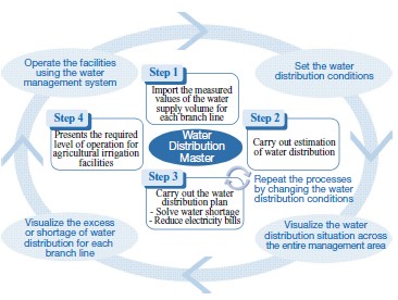
The procedure for creating a water distribution plan using this tool is shown in the figure. In Step 1, the data on the volume of supply water obtained from the water management system is imported. In Step 2, the crop conversion rate for each field, the operating rate of the pumps at the pumping station, and the volume of water drawn from agricultural irrigation facilities that cannot be obtained from the water management system, are entered. Then, the distribution situation of water in the main lines, which are the main arteries of water distribution, and in the branch lines, which distribute water to each field, are estimated and displayed. The water distribution situation can be displayed as a network diagram or a bar graph. In Step 3, if there is an uneven distribution of water to each branch line, the amount of water supplied from the dam is adjusted among the branch lines to resolve the uneven distribution. If the excess or shortage of water supply on the branch lines cannot be resolved by adjusting the amount of water supplied from the dam alone, a water distribution plan is created that will lead to the resolution of excess or shortage of water supply by repeatedly adjusting the amount of water drawn from the regulating reservoirs on each branch, the pumping stations, and the facilities that reuse upstream drainage, as well as the operating rate of the pumps. Land improvement district staff will then refer to this water distribution plan to operate the agricultural irrigation facilities and adjust the volume of water supplied to the branch lines.
Case study of using Water Distribution Master
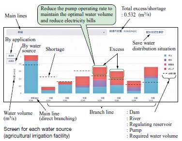
This tool visualizes the disparity between the volume of water needed and the volume of water supplied for each branch line, and shows the volume of water supplied by color-coding each water source. By displaying the water distribution situation not only in terms of total volume but also by color-coding each water source, it becomes easier to understand which agricultural irrigation facilities need to adjust their water supply volume if there are branch lines that are over-distributing water. This will help reduce electricity costs by lowering the operating rates of energy-intensive pumping stations and pumps in the agricultural irrigation facilities, for example.
Under the current water distribution management, when a farmer requests an increase in water supply, staff visits the site to operate the sluice gates to adjust the water distribution, resulting in wasted effort such as the need to travel to the site. Using this tool, however, can improve work efficiency by checking the uneven water distribution situation in advance and adjusting the water distribution remotely before receiving a request from a farmer.
Future initiatives
In rural areas, various issues are emerging and worsening, including rising electricity costs and crop damage caused by drought. IHI will continue to engage with our customers, analyze challenges, and offer tailored solutions.